The map
⇦ Tillbaka
A map is a reduced and simplified representation of the real world.
The orienteering map is specifically developed to be used in orienteering and meet the requirements for what a map should look like. This set of requirements regarding the content of the map is called the Specification for Orienteering Maps and applies internationally. The map is made up of different map features and colours that symbolize different objects and surfaces in the terrain.
PDF with map features
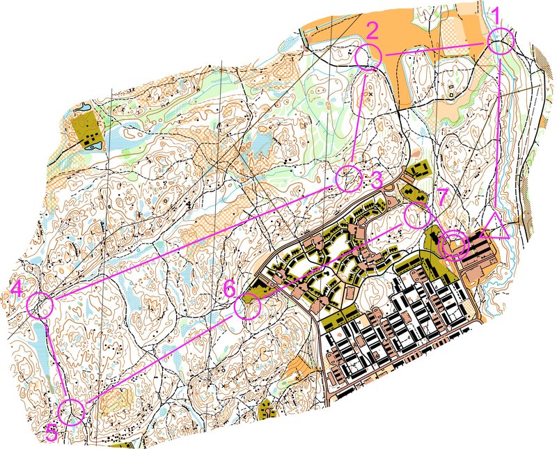
This is what a course in orienteering can look like. The start is marked with a triangle on the map, the controls with numbered circles and the finish with a double circle. The controls must be visited in numerical order.
The map scale
There are maps in different scales. The scale shows how much the map is scaled down in relation to the reality. In competitions and exercise events, a scale of 1:10 000 and 1:7 500 is often used. A simple rule om thumb is to delete the last two digits of the scale to find out how many meters one centimetre on the map is in reality. 1 cm on the map is thus 100 m in reality.
In sprint distance competitions, a scale of 1:5 000 or 1:4 000 is used.
History
In the beginning, the sport of orienteering was practised on maps with a scale of 1:100 000, but the map scale has been enlarged gradually. The decision to start using 1:15 000 as the basic scale was made in 1977.
Equidistance
Equidistance describes the height difference between two contour lines (the brown lines) on a map. If the map has an equidistance of 5 meters, there is a difference of 5 meters in height between each contour line.
Maps in orienteering has 2,5- or 5-meter equidistance as a standard. Which one that is chosen depends on the variation in elevation of the terrain. In flat terrain 2,5 meters is chosen while 5 meters is standard for more hilly terrain.
Orientate the map
By holding the map in the right direction, it becomes much easier to read and translate the map and terrain against each other. Orientate the map means that the north side of the map (the top edge) is in line with the north side of the compass needle (the red end). If you do not have a compass, it is possible to orientate the map according to the terrain. Imagine the map as a piece of a puzzle, which means that it only fits in one way in the terrain.
Try to always keep the map correctly oriented. This means that when you change direction of yourself, for example if the path you are following makes a turn, you must orientate the map again.
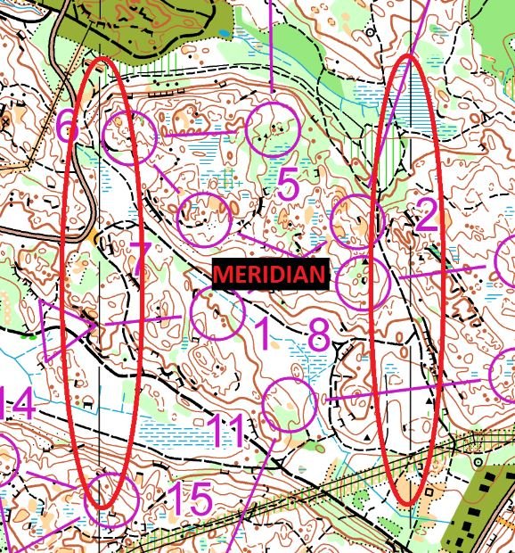
Meridian lines
At all maps in orienteering there is thin black or blue lines that run across the map in a north-south direction. These lines are called the meridians. The meridian lines help you to orientate your map to the north together with the compass. Be careful what the north (top edge) and south side of the map is so that you do not confuse them with each other and hold the map 180 degrees in the wrong direction. That is commonly referred to as a 180-degree error.
Fun fact
The word meridian line has its origin in the latin word for dinner, meridies, and refers to that all places along the same meridian have dinner at the same time.