⇦ Tillbaka
How do you learn orienteering? How do you become a better orienteer? What do you need to know about orienteering?
Would you like to get started and learn how to achieve orienteering?
In the following texts, you can read about meaningful parts and basics for practicing orienteering, either as a sport or a as an outdoor activity. Read it through, and if you thereafter need some help to get started, the recommendation is to get in contact with your closest orienteering club. In Sweden there is around 560 clubs who offers beginner courses for children, adolescents, and adults.
You can find the club and/or course closest to you at our website Hitta orientering.
The five foundations of orienteering
Orienteering can be explained as consisting of five foundations. To have the knowledge about these and be able to apply them out in the nature is crucial when practising orienteering.
- Understanding where you are on the map and where you are going
- Orientate your map
- Choose and plan your route
- Going from A to B
- Find the control
READ MORE ABOUT THE DIFFERENT FOUNDATIONS HERE.
Film about the map
Film about planning your route
Film about finding your way
The course
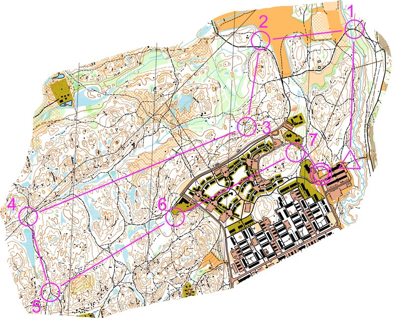
Here is an orienteering course with a start (triangle), controls (numbered circles) and finish (double circle). The controls must be taken in numerical order. The most common type of orienteering is to get around a course like this.
The map
A map is a reduced and simplified representation of reality. There are different kinds of maps that serves different purposes. Orienteering maps are specifically created for usage within orienteering and meet the requirements for what the map should look like. This set of requirements regarding the content of the map is called the Specification for Orienteering Maps. The map is made up of different map features and colours that symbolizes different objects and surfaces in the terrain.
Map features
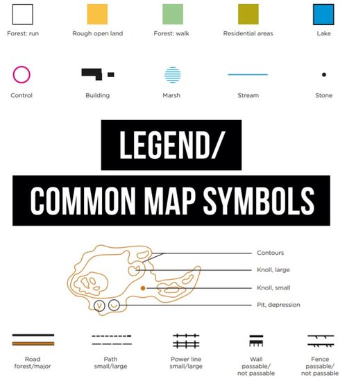
PDF with more map features
Map scale
There are maps in different scales. The scale presents how much the map is scaled down in relation to the reality. In competitions and exercise events, a scale of 1:10 000 and 1:7 500 is often used. A simple rule of thumb is to delete the last two digits of the scale to find out how many meters one centimetre on the map is in reality. 1 cm on the map is thus 100 m in reality.
In sprint distance competition, a scale of 1:5 000 or 1:4 000 is used.
History
In the beginning, the sport of orienteering was practised on maps with a scale of 1:100 000, but the map scale has been enlarged gradually. The decision to start using 1:15 000 as the basic scale was made in 1977.
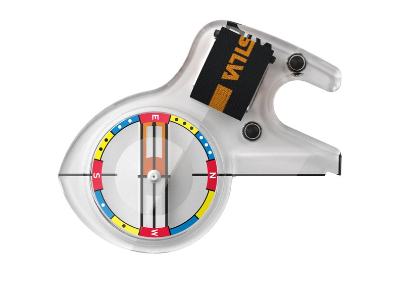
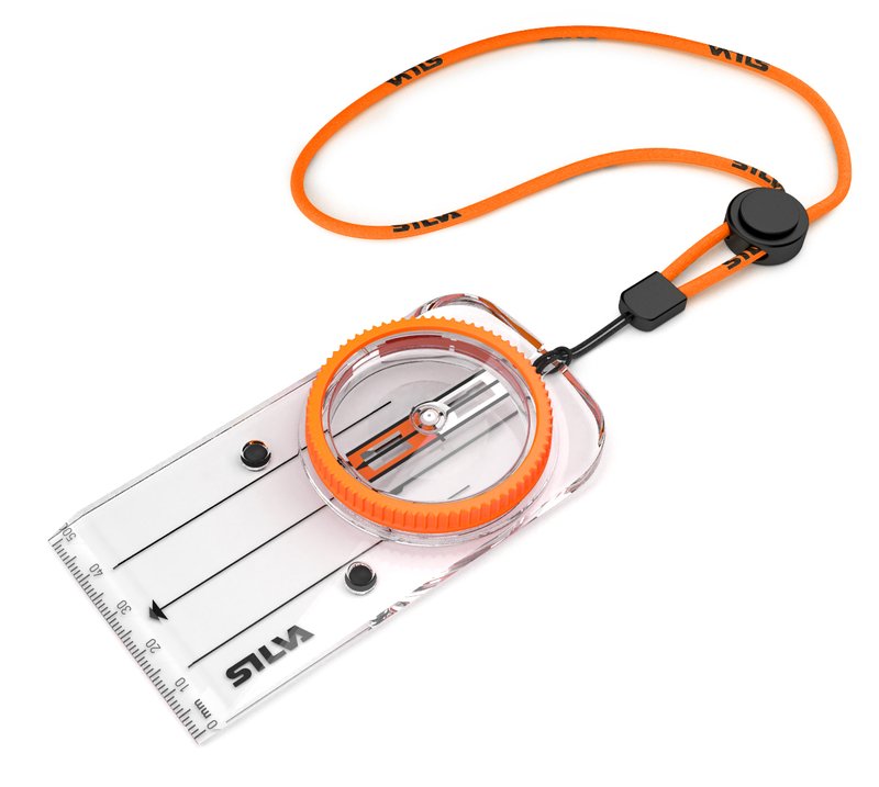
The compass
THUMB COMPASS AND BASEPLATE COMPASS
In orienteering, two types of compasses are mainly used: the thumb compass and the baseplate compass. They both work in the same way, and it is mostly a matter of individual preferences which one you choose. The majority of orienteers prefer the thumb compass which is considered a little easier and smoother you use.
Look at the tab “COMPASS” to find out more information and read about how to measure a compass bearing.
The control description
The control description, or the control definition as it is also called, is intended to give detailed information about the course and the controls. Each control has a unique code number printed on it and is described at the control description. The code number confirms that you are at the correct control point. The description also contains information about which terrain object the control is located at and on which side of, e.g. the east side of a boulder.
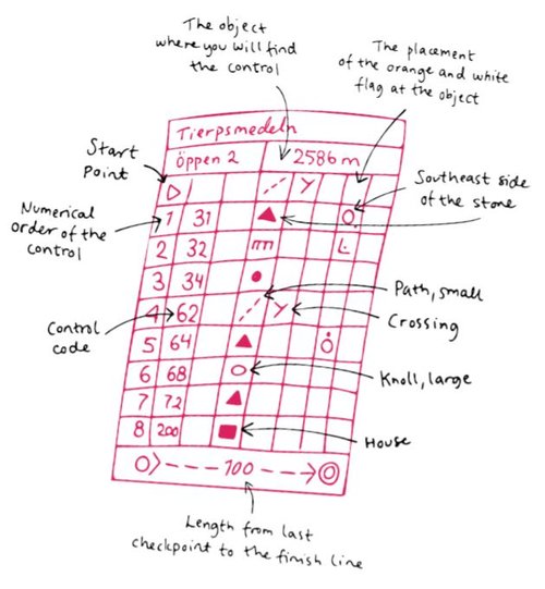
The control description is usually printed directly on the map, but for those who prefer to wear it in a special “definition holder” on their arm, separate copies are available as well.
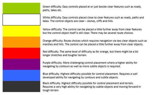
CLASSES AND LEVELS OF DIFFICULTY
Generally, there are two types of classes in orienteering competitions – open classes and age- and gender-divided classes. Open classes are available at different levels of difficulty and length, and you can choose the course you prefer, and think is suitable. In these classes you can register on site and start whenever you want. Age- and gender-divided classes on the other hand, have their given level of difficulty and length according to the competition distance. These classes are available from 10 years up to 95 years. In contrast to the open classes, you need to register in advance, and you will be assigned a start time.
Classification of levels of difficulty
THE FOUR DISCIPLINES IN ORIENTEERING
Distances
There are five individual distances in foot orienteering.
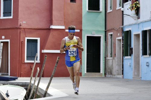
Sprint distance
The shortest and most intense distance. A large number of controls, quick decisions and small margins. The orienteering is relatively simple, often in urban environment, but becomes difficult due to the high speed. The winning time is about 12-15 minutes
Middle distance
Controls close to each other, frequent changes of direction, quick decisions and technically challenging. The winning time is about 30-35 minutes.
Long distance
Characterized by longer distances between controls where the choice of route is crucial. The senior elite athletes are challenged by long and physically demanding courses where the winning time is up to 95 minutes.
Ultra-long distance
The longest and toughest distance where the physical capacity as well as route choices are crucial. The winning time is 2-3 hours.
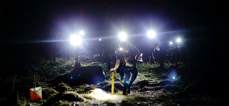
Night orienteering
The most mythical distance. Similar to the long distance, the distances between controls are long and the choice of route is therefore of great importance. The challenge is expanded as you perform it in the dark, aided with a headlamp. The most difficult orienteering possible, which gives a high sense of joy to master.
In addition to the individual distances, there are relays ranging from two to 25 runners. There are usually separate relays for men and women, but there are also relays with mixed teams.
THE RIGHT OF PUBLIC ACCESS – THE ORIENTEER AS A GUEST IN THE NATURE
As orienteers, we are guests of the nature. Nature is our athletic ground and sports field, but it is also a living environment for plants and animals which we therefore must care for and be considerate about. We are also guests of the ground landlord, and therefore it is obvious that the interests of the landowners need to be considered.
Learn more
The Swedish Orienteering Federation together with SISU Förlag, has produced literature for those who want to learn more about orienteering, both for those who are beginners and more experienced orienteers. Currently they are all written in swedish unfortunately, except for the folder Orienteering for beginners.
Recommended literature:
Hitta rätt - an introduction of the map and compass. Perfect for the beginner to gain some knowledge about the basics of orienteering.
Orientering för nybörjare folder - The most important information for understanding orienteering and how a competition is working. Buy the folder in our webshop, go to "lärmaterial och kompasser". It is also available in english.
You can also download the folder:
Orientering för nybörjare folder på svenska
Orienteering for beginners folder in english